
Reviewed · SCENIC HELICOPTER FLIGHTS
Mt. Tarawera Volcano Scenic Floatplane Tour from Rotorua
A water takeoff on Lake Rotorua sets this tour apart before you even reach Mt. Tarawera. You’ll fly along the volcano’s jagged 8-kilometer rift, then sweep over hot lakes, crater country, geysers, and steaming cliffs in one short loop. The aerial view gives you the big picture that ground tours cannot.
I like the small group size, capped at 10, and the chance to choose a morning or afternoon departure. I also like the pilot-guided commentary, which turns a pretty flight into a quick lesson in Rotorua’s volcanic past. The main drawback is the 30-minute length: at about $242.02 per person, this is a special splurge, not a cheap sightseeing ride. Bad weather can also postpone the flight.
Key points at a glance
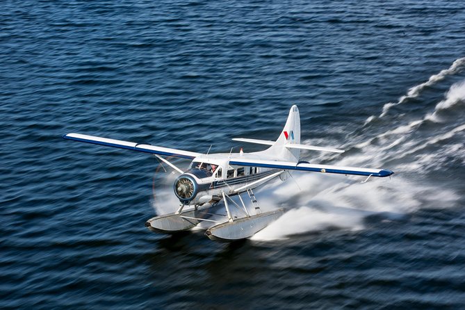
- Water takeoff and landing: Start and finish on Lake Rotorua for a memorable seaplane experience.
- Mt. Tarawera from above: See the volcano’s long eruption rift, jagged summit, and crater lakes in one sweeping view.
- A full volcanic circuit: The route also covers Waimangu Volcanic Valley, the Blue and Green Lakes, Whakarewarewa, and Sulphur Bay.
- Pilot commentary: Your pilot serves as both aviator and guide, explaining the sights during the flight.
- Small aircraft, small group: The maximum is 10 passengers, with a 297-pound, or 135-kilogram, per-seat limit.
- Weather matters: The flight requires good conditions, and poor weather may lead to a new date or full refund.
Why the Lake Rotorua takeoff matters
Most scenic flights begin on a runway. This one begins with the floatplane skimming across Lake Rotorua before lifting into the air. That short burst of spray and motion gives the trip a clear sense of occasion, without adding much time.
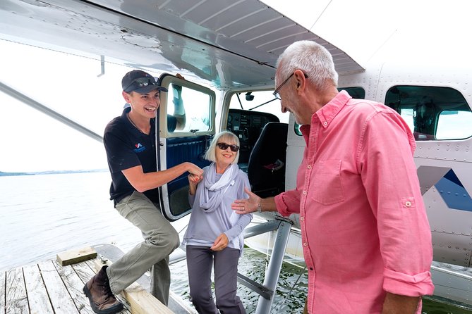
You meet beside Lake Rotorua on Lakefront Drive in the Ohinemutu area. Hotel pickup is not included, so you’ll need to make your own way to the waterfront. The meeting point is near public transportation, which makes it fairly practical if you are staying in Rotorua.
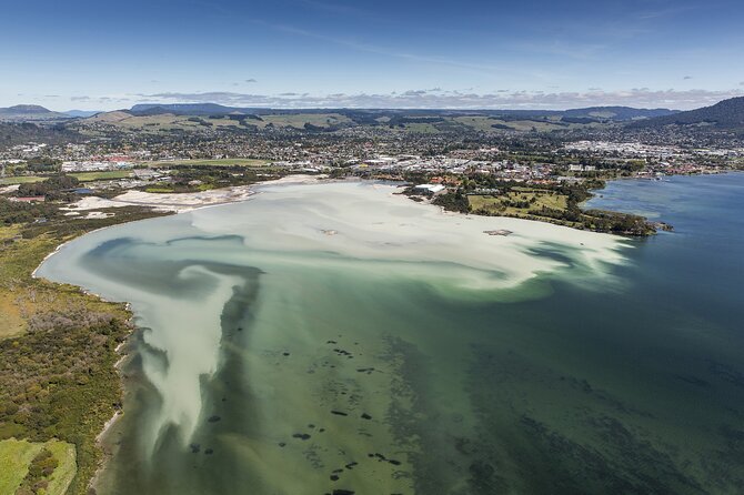
From the air, the lake gives you an immediate sense of place. You can look back toward the city, across the water, and toward the volcanic features that define this part of the North Island. One passenger specifically enjoyed seeing black swans on the lake, a small detail that can make the opening minutes feel more connected to Rotorua rather than like a generic flight.
The water landing at the end is just as important as the takeoff. You finish with a low approach and splashdown on Lake Rotorua, then return to the same waterfront meeting point. For a 30-minute outing, those two water movements provide much of the thrill.
More scenic helicopter flights in Rotorua:
- Mt Tarawera Helicopter Tour with Volcano Landing
★ 5.0 · 40 reviews - Rotorua: Scenic Flight over Mt Tarawera & Waimangu Valley
★ 4.9 · 25 reviews - 15-Minute Crater Lakes Flight by Floatplane from Rotorua
★ 4.5 · 11 reviews
The route from Mokoia Island to Mt. Tarawera
After leaving the lakefront, the plane heads toward Mokoia Island and the crater-lake country. This opening section helps you see how much volcanic activity has shaped the region. From ground level, Rotorua’s lakes can seem separate. From above, they form part of a larger volcanic system.
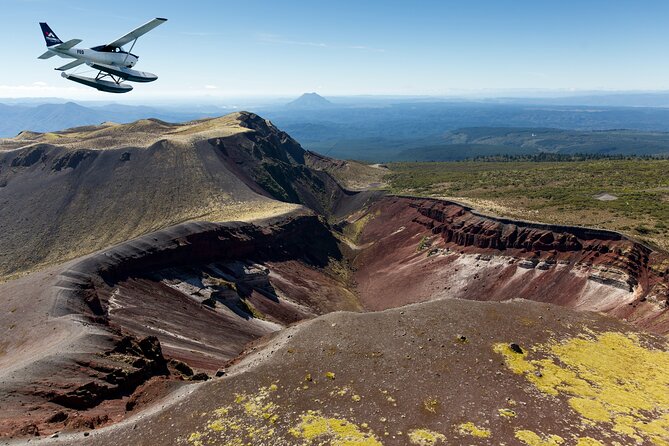
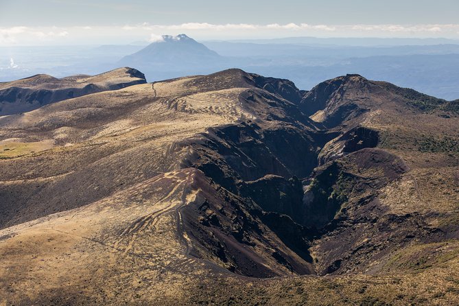
The central sight is Mt. Tarawera, a volcano tied to Māori legend and the major eruption of 1886. From the plane, you follow an approximately 8-kilometer rift along the summit. The broken ridge, dark rock, and crater lakes create a stark, almost lunar view.
This is where the floatplane has a real advantage over a standard lake cruise. A boat can show you the water and nearby shore. A road tour can bring you closer to selected viewpoints. From above, you can see the full shape of the eruption zone and how the cracks run across the mountain.
The short flight also lets you view Mt. Tarawera without committing several hours to a land excursion. That matters if your Rotorua schedule already includes Māori cultural activities, geothermal walks, or a trip to another part of the region.
Your pilot’s narration adds useful context. The commentary is not a separate lecture, so you receive information while looking at the feature itself. Pilot Katie received particular praise for clear commentary and for taking good care of a passenger with a back injury. That suggests the crew pays attention to individual needs, though you should still raise any mobility or comfort concerns before flying.
Waimangu’s steaming cliffs and hot lakes
From Mt. Tarawera, the aircraft continues toward Waimangu Volcanic Valley. This section shifts from the broad, rugged form of the volcano to a more active-looking geothermal setting.
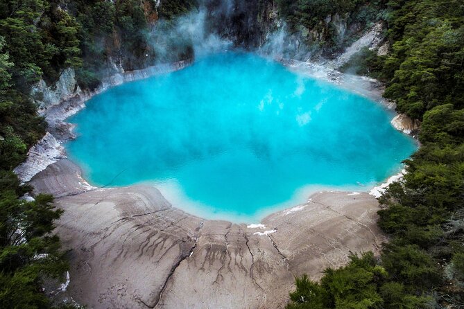
You’ll see steaming cliffs and hot lakes from above. The view shows how geothermal features sit within the surrounding forest and volcanic terrain, rather than appearing as isolated pools. That wider view can be especially useful if you plan to visit Waimangu on foot later.
The aerial perspective also helps explain Rotorua’s constant mix of water, heat, and volcanic rock. You may see features that are difficult to connect when viewed from a path or road. At the same time, you should not expect the same close sensory experience as a ground visit. The plane cannot give you the smell of sulphur, the sound of bubbling water at close range, or the chance to pause beside a hot lake.
This distinction matters when you decide how to spend your money. The flight is best as an overview and a memorable ride. It should not replace a geothermal walk if you want close-up detail.
Blue and Green Lakes on the return flight
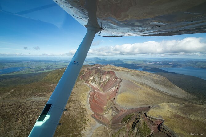
The route then swings back toward Rotorua over the Blue and Green Lakes. From above, the color contrast is one of the most attractive parts of the trip. The plane gives you a clean view of both bodies of water and their position within the surrounding terrain.
These lakes can be difficult to appreciate fully from a road. Trees, shorelines, and viewing angles limit what you see at ground level. From the aircraft, their shape and color become much clearer, and you get a better sense of the scale of the area.
This is also a good moment for photographs. The plane keeps moving, so you won’t have unlimited time to compose each shot. A camera or phone with a quick point-and-shoot setup will be more useful than equipment that takes a long time to adjust. Window reflections, glare, and the position of your seat can affect your pictures, so treat photography as a bonus rather than the sole reason to book.
The flight’s compact route works well here. In roughly half an hour, you see several major Rotorua sights from different angles. You will not linger over each one, but you avoid spending much of your day driving between them.
Same base, a different kind of day:
- Rotorua Canopy Tours: 2.5Hour Native Forest Zipline Adventure
★ 5.0 · 4,563 reviews - Mitai Maori Village: Cultural Experience and Dinner Buffet
★ 4.7 · 3,575 reviews - Rotorua: Wai-O-Tapu Geothermal Park Entry Ticket
★ 4.6 · 2,601 reviews - Rotorua’s Ultimate Zipline: 6 ziplines, 400 m Tandem, Cliff Walk
★ 5.0 · 2,557 reviews
Whakarewarewa, Sulphur Bay, and the final approach
The final part of the circuit passes over Whakarewarewa Thermal Reserve and Sulphur Bay before returning to Lake Rotorua. Whakarewarewa brings the route back toward Rotorua’s better-known geysers and geothermal activity.
From the air, the gurgling geysers and steaming ground form a striking contrast with the lake and city nearby. You can see how close the thermal reserve is to everyday Rotorua life. That mix of town, water, and volcanic heat is one of the reasons an aerial trip adds something to a normal sightseeing plan.
One point in the feedback is worth noting: a passenger enjoyed the seaplane and the scenery but wished the flight would go over the thermal fields. The published route does pass over Whakarewarewa and its geysers, but the exact views depend on the aircraft’s path, weather, and visibility. If geothermal fields are your main goal, ask the operator about the current route before booking and keep expectations realistic.
The return across Sulphur Bay leads to the water landing. You end where you started, without a separate transfer or long walk to another pickup point. Since the flight is short, this simple finish helps the experience fit neatly around other Rotorua plans.
What the pilot adds to the flight
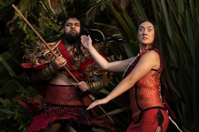
The pilot is more than someone handling the aircraft. You receive live commentary about Mt. Tarawera, the eruption zone, geothermal areas, and the lakes below. That makes a difference on a route where many sights can look similar if you do not know what you are seeing.
The best feedback centers on three things: professional flying, warm service, and useful narration. A pilot named Katie was singled out for both her commentary and her care toward a passenger with a back injury. Other comments describe the crew as friendly and attentive, with good communication before the trip.
You should still remember that the commentary takes place in a small aircraft. Engine noise and the position of your seat may make some words harder to hear. If a fact or place matters to you, ask when you can. The flight is a shared experience, not a private guide service.
The maximum group size is 10, which keeps the plane smaller than a large sightseeing operation. That does not guarantee a private flight, but it does make the setting more personal and gives the pilot a manageable group to address.
Is 30 minutes enough for $242.02?
The listed price is about $242.02 per person, and the flight lasts approximately 30 minutes. On a strict cost-per-minute basis, it is expensive. You are paying for the aircraft, the water operation, the pilot, and access to views that would take far longer to gather by road and on foot.
I think the value improves if you treat this as two experiences in one: a seaplane ride and a concentrated survey of Rotorua’s volcanic region. The water takeoff and landing provide the adventure. The route over Mt. Tarawera, Waimangu, the lakes, and Whakarewarewa provides the sightseeing.
It is less convincing value if you only want a long, relaxed flight. Thirty minutes passes quickly, especially when the aircraft is moving over several major sights. You may feel that the flight ended just as you settled into the view.
The tour is also useful for a tight itinerary. You can choose a morning or afternoon departure, then plan other Rotorua activities around it. The booking pattern suggests people reserve well ahead, with an average lead time of 37 days, so I would not leave this until the last moment if your schedule is fixed.
Weather, comfort, and practical details
This experience needs good weather. Rain, cloud, or poor visibility can reduce the value of the flight, and bad conditions may lead to postponement. One booking was moved by 24 hours because of rain, and the later flight was disappointing because the weather remained poor. That is an important warning: the aircraft may operate safely while the views are still limited.
If the operator cancels because of weather, you are offered another date or a full refund. You can also cancel for a full refund if you do so at least 24 hours before the start time. Changes or cancellations inside that 24-hour window are not accepted for a refund.
The per-seat limit is 297 pounds, or 135 kilograms. This is listed as an aircraft comfort and balance rule, so check it before booking if it may apply to you. Most people can participate, but anyone with back, mobility, or other physical concerns should discuss them with the operator in advance.
Food and drinks are not included. The flight begins and ends at the lakefront, so plan your meal before or after rather than expecting refreshments as part of the activity.
Who should book this flight?
I would recommend it to you if you want to see the structure of Rotorua’s volcanic region in one quick outing. It suits photographers, first-time visitors with limited time, and anyone who likes the idea of a water aircraft as much as the views themselves.
It also works well for people who have already visited one geothermal park and want a broader picture. From above, the route links lakes, volcanoes, steam, geysers, and the city in a way that no single walking route can.
You may want to skip it if your budget is tight or if you prefer slow, close-up sightseeing. A land visit gives you more time at each geothermal feature for less money. You should also avoid booking it as the only fixed activity on a weather-sensitive day, since cloud or rain can change the experience and the schedule.
With a 4.8 rating from 42 ratings and 95 percent recommendation, the experience has a strong record. The most consistent praise goes to the scenery, water operation, pilot service, and commentary. The main caution is equally clear: weather controls the quality of the views.
Should you book the Mt. Tarawera floatplane tour?
Book it if you want a short, high-impact look at Rotorua from above and you value the thrill of taking off and landing on water. The combination of Mt. Tarawera, Waimangu, the Blue and Green Lakes, and Whakarewarewa makes good use of the 30 minutes.
I would book it early, leave room in your schedule in case weather causes a delay, and think of the $242.02 price as a special outing rather than routine transport. For a memorable overview of Rotorua’s volcanic country, it is a strong choice. For close contact with geothermal features or the best bargain, choose a ground tour instead.
FAQ
How long is the Mt. Tarawera floatplane tour?
The scenic flight lasts approximately 30 minutes.
Where does the tour begin?
You meet at Lakefront Drive, Ohinemutu, Rotorua 3010, New Zealand, beside Lake Rotorua.
Where does the tour end?
The flight ends back at the same meeting point beside Lake Rotorua.
Does the floatplane take off and land on water?
Yes. The aircraft takes off from and lands on Lake Rotorua.
What sights does the flight cover?
The route includes Mokoia Island, Mt. Tarawera, the crater lakes, Waimangu Volcanic Valley, the Blue and Green Lakes, Whakarewarewa Thermal Reserve, and Sulphur Bay.
How many people can join the flight?
The maximum group size is 10 travelers.
Is there a passenger weight limit?
Yes. The maximum per-seat limit is 297 pounds, or 135 kilograms, for aircraft comfort and balance.
What happens if bad weather cancels the flight?
You will be offered a different date or a full refund. You can also cancel at least 24 hours before the start time for a full refund.
Just added in Rotorua
- 15-Minute Crater Lakes Flight by Floatplane from Rotorua★ 4.5 · 11 reviews
- Whaka Geothermal Trails Self-Guided Tour★ 3.5 · 44 reviews
- Rotorua: Scenic Flight over Mt Tarawera & Waimangu Valley★ 4.9 · 25 reviews
- Mt Tarawera Helicopter Tour with Volcano Landing★ 5.0 · 40 reviews
- Rotorua Highlights Inc. Te Puia & Secret Spot Hot Tubs Day Tour★ 4.5 · 129 reviews
- Lake Rotoiti Evening Kayak Tour including Hot Springs, Glowworm Caves and BBQ Dinner★ 5.0 · 60 reviews
- Mountain Jade Highlights Tour★ 5.0 · 31 reviews
- Rotorua: Redwoods Altitude High Ropes Adventure★ 4.9 · 165 reviews
Scenic Helicopter Flights, compared.
Franz Josef Glacier: Helicopter Flight & Alpine Landing
Read our review →
Franz Josef & Fox Glaciers Helicopter Flight & Snow Landing
Read our review →
Pilot’s Choice: 2 Glaciers & Snow Landing – 35min
Read our review →
Milford Sound Small Group Tour from Queenstown with Scenic Flight
Read our review →Browse the lists this tour appears in